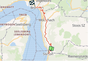
Trail Other activity Sisikon - Sisikon - Brunnen - Photo

Sisikon - Brunnen

 jschna
jschna

User

© OpenStreetMap contributors
Length
Length
10.3 km
Max alt
Max alt
824 m
Uphill gradient
Uphill gradient
621 m
Km-Effort
Km-Effort  
18.6 km
Min alt
Min alt
436 m
Downhill gradient
Downhill gradient
627 m
Boucle
Boucle
No
Creation date :
2014-12-11 00:00:00.0
Updated on :
2014-12-11 00:00:00.0

(0 Reviews)

Other activity
Other activity
--
Difficulty : Unknown

Scan this QR Code to open this trail in the SityTrail application

FREE GPS app for hiking

Logo SityTrail SityTrail

IGN / Geographical institutes

Download SityTrail from the App Store Download SityTrail from Google Play

Logo SityTrail SityTrail Plus

The world is yours!

Download SityTrail from the App Store Download SityTrail from Google Play Download SityTrail on Huawei AppGallery

About

Trail Other activity of 10.3 km to be discovered at Uri, Unknown, Sisikon. This trail is proposed by jschna.

Description

Vom Bahnhof Sisikon steigt der Weg für ca. 45 Min. ziemlich steil an, dann gehts etwas gemächlicher. Stets eine wunderschöne Aussicht vor Augen, muss man von Zeit zu Zeit Pause machen und diese Rundsicht geniessen. Verpflegen kann man sich in Morschach, oder aber in Brunnen, wo das Angebot noch grösser ist. (In der Marschzeit sind auch ca. 40 Min. Pausen inbegriffen.)

Elevation profile

Positioning

Country:
Switzerland
Region :
Uri
Department/Province :
Unknown
Municipality :
Sisikon
Location:
Unknown
Start:(UTM)
471154 ; 5199579 (32T) N.


Close
My subscriptions