


17_lundi Bois d'Amont

jcm17
User
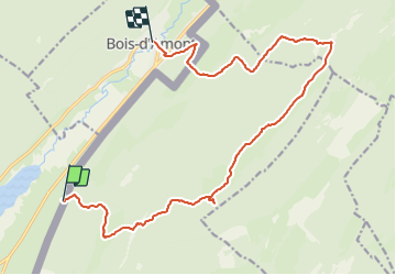

Length
17.4 km

Max alt
1523 m

Uphill gradient
633 m
Km-Effort
26 km

Min alt
1056 m

Downhill gradient
705 m
Boucle
No
Creation date :
2014-12-10 00:00:00.0
Updated on :
2014-12-10 00:00:00.0
5h32
Difficulty : Difficult

FREE GPS app for hiking
 SityTrail
IGN / Geographical institutes
SityTrail Plus
The world is yours!
About
Trail Walking of 17.4 km to be discovered at Bourgogne-Franche-Comté, Jura, Les Rousses. This trail is proposed by jcm17.
Description
groupe 1 Creux du Croue, Creux Devant, Mt Sala, Combe du Couchant, Begnines, Chalet Roch Dessus, Bois d'Amont
Positioning
Country:
France
Region :
Bourgogne-Franche-Comté
Department/Province :
Jura
Municipality :
Les Rousses
Location:
Unknown
Start:(Dec)
Start:(UTM)
278193 ; 5154044 (32T) N.
Comments