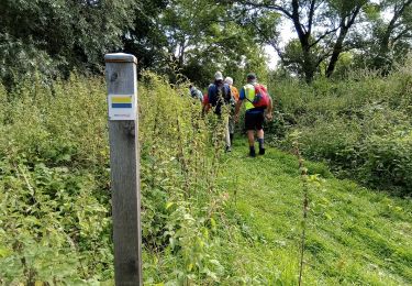
Trail Walking Tergnier - Tergnier ou la bataille du rail - Photo

Tergnier ou la bataille du rail

Randonnées de RandoFamili

© OpenStreetMap contributors
Length
Length
10.9 km
Max alt
Max alt
79 m
Uphill gradient
Uphill gradient
53 m
Km-Effort
Km-Effort  
11.6 km
Min alt
Min alt
48 m
Downhill gradient
Downhill gradient
53 m
Boucle
Boucle
Yes
Creation date :
2014-12-10 00:00:00.0
Updated on :
2014-12-10 00:00:00.0

(0 Reviews)

Walking
Walking
--
Difficulty : Unknown

Scan this QR Code to open this trail in the SityTrail application

FREE GPS app for hiking

Logo SityTrail SityTrail

IGN / Geographical institutes

Download SityTrail from the App Store Download SityTrail from Google Play

Logo SityTrail SityTrail World

The world is yours!

Download SityTrail from the App Store Download SityTrail from Google Play Download SityTrail on Huawei AppGallery

About

Trail Walking of 10.9 km to be discovered at Hauts-de-France, Aisne, Tergnier. This trail is proposed by Rando Famili.

Description

Ville-champignon érigée autour des rails, Tergnier est un noeud ferroviaire qui a toujours joué un rôle stratégique lors des campagnes militaires. Plusieurs fois reconstruites, la cité affiche ostensiblement le style de la Reconstruction, marque de l'Histoire dans laquelle elle occupe une place à part.

Elevation profile

Photos

Points of interest

Point of interest Tergnier - Musée de la Résistance et de la Déportation de Picardie - Photo
Rando Famili
Point of interest Tergnier - Base nautique de la Frette - Photo
Rando Famili
Point of interest Tergnier - La Cité Cheminote - Photo
Rando Famili
Point of interest Tergnier - Club de voile de Tergnier - Photo
Rando Famili
Point of interest Tergnier - Le style de la Reconstruction - Photo
Rando Famili
Point of interest Tergnier - Le Paon - Photo
Rando Famili
TERGNIER 
Point of interest Tergnier - Le musée de la Résistance - Photo
Rando Famili

Positioning

Country:
France
Region :
Hauts-de-France
Department/Province :
Aisne
Municipality :
Tergnier
Location:
Fargniers
Start:(Dec)
Start:(UTM)
522722 ; 5500708 (31U) N.

Trails nearby

Trail Walking Beautor - Beautor 2 - Photo
Walking
VANDERPUTTENMi

Walking

Medium
Beautor, Hauts-de-France, Aisne, France
11.1 km | 11.7 km-effort
2h 19min
Yes
Trail Walking Beautor - Beautor 1 - Photo
Walking
VANDERPUTTENMi

Walking

Medium
Beautor, Hauts-de-France, Aisne, France
8.1 km | 8.6 km-effort
1h 50min
Yes
Trail Road bike Tergnier - retour la frette - Photo
Road bike
jojo02

Road bike

Easy
(1)
Tergnier, Hauts-de-France, Aisne, France
10.7 km | 11.4 km-effort
28min
No
Trail Walking Tergnier - rando canal  - Photo
Walking
Jojo-02

Walking

Very easy
Tergnier, Hauts-de-France, Aisne, France
3.3 km | 3.5 km-effort
43min
Yes
Trail Mountain bike Beautor - Circuit 20.1 km VTT départ piscine Beautor_backup - Photo
Mountain bike
Jojo-02

Mountain bike

Easy
Beautor, Hauts-de-France, Aisne, France
20 km | 21 km-effort
1h 25min
Yes
Trail Walking Servais - Circuit 10.9 km départ Servais - Photo
Walking
Jojo-02

Walking

Easy
Servais, Hauts-de-France, Aisne, France
10.8 km | 11.8 km-effort
2h 38min
Yes


Close
My subscriptions