Trail Walking Lewarde - Circuit de la fosse Delloye - Photo

Circuit de la fosse Delloye

Randonnées de RandoFamili

© OpenStreetMap contributors
Length
Length
9.5 km
Max alt
Max alt
73 m
Uphill gradient
Uphill gradient
85 m
Km-Effort
Km-Effort  
10.6 km
Min alt
Min alt
19 m
Downhill gradient
Downhill gradient
84 m
Boucle
Boucle
Yes
Creation date :
2014-12-10 00:00:00.0
Updated on :
2014-12-10 00:00:00.0

(0 Reviews)

Walking
Walking
--
Difficulty : Unknown

Scan this QR Code to open this trail in the SityTrail application

FREE GPS app for hiking

Logo SityTrail SityTrail

IGN / Geographical institutes

Download SityTrail from the App Store Download SityTrail from Google Play

Logo SityTrail SityTrail World

The world is yours!

Download SityTrail from the App Store Download SityTrail from Google Play Download SityTrail on Huawei AppGallery

About

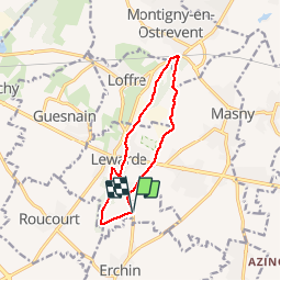
Trail Walking of 9.5 km to be discovered at Hauts-de-France, Nord, Lewarde. This trail is proposed by Rando Famili.

Description

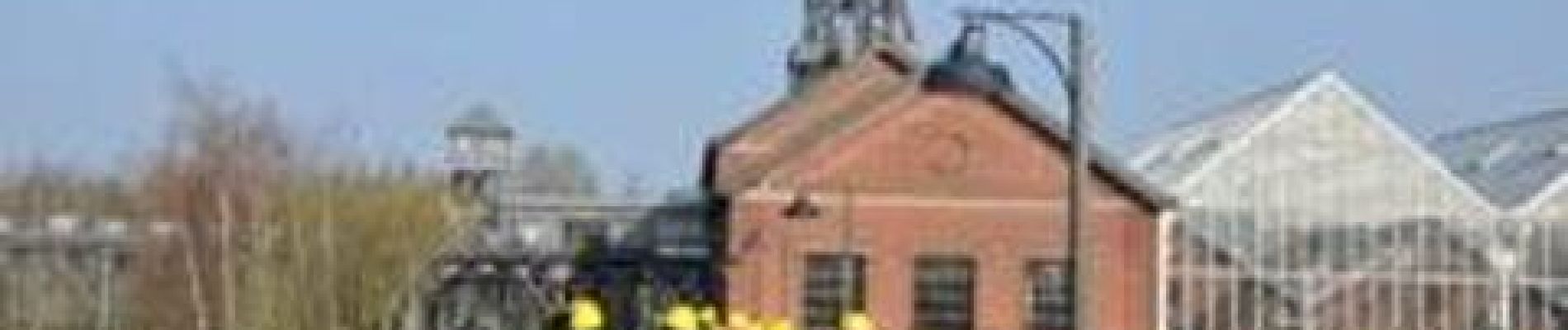
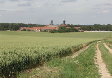
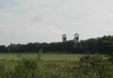
« La mine sans dessus dessous ! »
Tiens, un chevalement ! Et là, c’est l’ancienne mine…Tu crois qu’on peut visiter une vraie galerie sous-terraine ? Allons plutôt au Centre Historique Minier,  pour mieux comprendre l’aventure minière de la région sur près de trois siècles !

Elevation profile

Photos

Points of interest

Point of interest Lewarde - CENTRE HISTORIQUE MINIER DE LEWARDE - Photo
Rando Famili
Point of interest Lewarde - Le Centre Historique Minier de Lewarde - Photo
Rando Famili
Point of interest Lewarde - FR - les cites minieres - randofamili - Photo
Rando Famili
Point of interest Lewarde - FR - Au fond de la mine - randofamili - Photo
Rando Famili

Positioning

Country:
France
Region :
Hauts-de-France
Department/Province :
Nord
Municipality :
Lewarde
Location:
Unknown
Start:(Dec)
Start:(UTM)
512263 ; 5575330 (31U) N.

Trails nearby

Trail Mountain bike Sin-le-Noble - Le chemin des Galibots - Sin-Le-Noble. - Photo
Mountain bike
tracegps

Mountain bike

Medium
(2)
Sin-le-Noble, Hauts-de-France, Nord, France
35 km | 38 km-effort
3h 0min
Yes
Trail Walking Bruille-lez-Marchiennes - Sentier de la Motte - Bruille lez Marchiennes - Photo
Walking
tracegps

Walking

Easy
(1)
Bruille-lez-Marchiennes, Hauts-de-France, Nord, France
4.8 km | 5.1 km-effort
1h 30min
Yes
Trail Walking Écaillon - Circuit des Sources - Ecaillon       - Photo
Walking
tracegps

Walking

Medium
Écaillon, Hauts-de-France, Nord, France
6.5 km | 7 km-effort
1h 40min
Yes
Trail Walking Écaillon - Chemin des Braconniers - Ecaillon - Photo
Walking
tracegps

Walking

Easy
Écaillon, Hauts-de-France, Nord, France
4.5 km | 4.8 km-effort
1h 10min
Yes
Trail Walking Villers-au-Tertre - Au départ du Mont Tilleul  (Villers-au-tertre) - Photo
Walking
tracegps

Walking

Easy
Villers-au-Tertre, Hauts-de-France, Nord, France
8.7 km | 9.5 km-effort
2h 0min
Yes
Trail Walking Lewarde - Circuit de la Fosse Delloye - Lewarde - Photo
Walking
tracegps

Walking

Medium
(1)
Lewarde, Hauts-de-France, Nord, France
9.5 km | 10.6 km-effort
2h 25min
Yes
Trail Walking Masny - A l'aube de nos villages - Masny - Photo
Walking
tracegps

Walking

Medium
Masny, Hauts-de-France, Nord, France
10.6 km | 11.4 km-effort
2h 40min
Yes
Trail Walking Montigny-en-Ostrevent - Circuit du bois de Montigny -  Montigny-en-Ostrevent - Photo
Walking
tracegps

Walking

Medium
Montigny-en-Ostrevent, Hauts-de-France, Nord, France
8.9 km | 9.7 km-effort
2h 15min
Yes
Trail Mountain bike Sin-le-Noble - La boucle du Vivier - Sin-Le-Noble - Photo
Mountain bike
tracegps

Mountain bike

Easy
Sin-le-Noble, Hauts-de-France, Nord, France
9.3 km | 10 km-effort
45min
Yes


Close
My subscriptions