


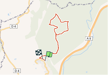
z le Capitou 29-01-19

cb8310
User

Length
7.6 km

Max alt
176 m

Uphill gradient
171 m
Km-Effort
9.9 km

Min alt
84 m

Downhill gradient
179 m
Boucle
Yes
Creation date :
2019-01-29 13:53:48.211
Updated on :
2019-01-30 09:33:54.026
--
Difficulty : Medium

FREE GPS app for hiking
 SityTrail
IGN / Geographical institutes
SityTrail Plus
The world is yours!
About
Trail On foot of 7.6 km to be discovered at Provence-Alpes-Côte d'Azur, Var, Fréjus. This trail is proposed by cb8310.
Description
rando de difficulté moyenne à travers l'Esterel par de larges pistes
Photos


Positioning
Country:
France
Region :
Provence-Alpes-Côte d'Azur
Department/Province :
Var
Municipality :
Fréjus
Location:
Unknown
Start:(Dec)
Start:(UTM)
316528 ; 4817884 (32T) N.
Comments