


frontenas

vaud
User
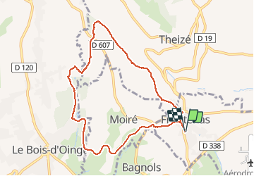

Length
8.8 km

Max alt
533 m

Uphill gradient
276 m
Km-Effort
12.5 km

Min alt
333 m

Downhill gradient
275 m
Boucle
Yes
Creation date :
2019-01-30 12:57:14.603
Updated on :
2019-01-30 16:03:37.067
3h04
Difficulty : Easy

FREE GPS app for hiking
 SityTrail
IGN / Geographical institutes
SityTrail Plus
The world is yours!
About
Trail Walking of 8.8 km to be discovered at Auvergne-Rhône-Alpes, Rhône, Frontenas. This trail is proposed by vaud.
Positioning
Country:
France
Region :
Auvergne-Rhône-Alpes
Department/Province :
Rhône
Municipality :
Frontenas
Location:
Unknown
Start:(Dec)
Start:(UTM)
625535 ; 5086904 (31T) N.
Comments