


20190205

Martinechampailler
User
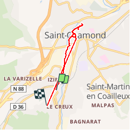

Length
5.3 km

Max alt
429 m

Uphill gradient
80 m
Km-Effort
6.3 km

Min alt
359 m

Downhill gradient
57 m
Boucle
No
Creation date :
2019-02-05 10:02:54.92
Updated on :
2019-02-05 11:58:26.396
57m
Difficulty : Very easy

FREE GPS app for hiking
 SityTrail
IGN / Geographical institutes
SityTrail Plus
The world is yours!
About
Trail Walking of 5.3 km to be discovered at Auvergne-Rhône-Alpes, Loire, Saint-Chamond. This trail is proposed by Martinechampailler.
Positioning
Country:
France
Region :
Auvergne-Rhône-Alpes
Department/Province :
Loire
Municipality :
Saint-Chamond
Location:
Unknown
Start:(Dec)
Start:(UTM)
617546 ; 5035337 (31T) N.
Comments