


Ibos Rs

LouisROGER
User GUIDE
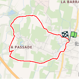

Length
4.5 km

Max alt
328 m

Uphill gradient
21 m
Km-Effort
4.8 km

Min alt
317 m

Downhill gradient
22 m
Boucle
Yes
Creation date :
2019-02-05 14:17:23.426
Updated on :
2019-02-05 15:59:53.391
1h41
Difficulty : Very easy

FREE GPS app for hiking
 SityTrail
IGN / Geographical institutes
SityTrail Plus
The world is yours!
About
Trail Walking of 4.5 km to be discovered at Occitania, Hautespyrenees, Ibos. This trail is proposed by LouisROGER.
Photos


Positioning
Country:
France
Region :
Occitania
Department/Province :
Hautespyrenees
Municipality :
Ibos
Location:
Unknown
Start:(Dec)
Start:(UTM)
256530 ; 4791065 (31T) N.
Comments