


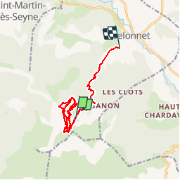
domaine VTT chabanon-selonnet

mapomme
User

Length
26 km

Max alt
1951 m

Uphill gradient
2065 m
Km-Effort
55 km

Min alt
1097 m

Downhill gradient
2722 m
Boucle
No
Creation date :
2014-12-10 00:00:00.0
Updated on :
2014-12-10 00:00:00.0
2h50
Difficulty : Unknown

FREE GPS app for hiking
 SityTrail
IGN / Geographical institutes
SityTrail Plus
The world is yours!
About
Trail Mountain bike of 26 km to be discovered at Provence-Alpes-Côte d'Azur, Alpes-de-Haute-Provence, Selonnet. This trail is proposed by mapomme.
Description
Télésiège: 1 verte 1 bleue 2 rouges descente "chevreuil" sur selonnet.
Positioning
Country:
France
Region :
Provence-Alpes-Côte d'Azur
Department/Province :
Alpes-de-Haute-Provence
Municipality :
Selonnet
Location:
Unknown
Start:(Dec)
Start:(UTM)
283552 ; 4913434 (32T) N.
Comments