


longet

motardes04
User
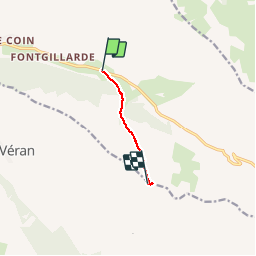

Length
4.2 km

Max alt
2713 m

Uphill gradient
681 m
Km-Effort
11 km

Min alt
2025 m

Downhill gradient
4 m
Boucle
No
Creation date :
2019-02-10 09:10:57.588
Updated on :
2019-02-10 13:50:37.986
2h28
Difficulty : Very easy

FREE GPS app for hiking
 SityTrail
IGN / Geographical institutes
SityTrail Plus
The world is yours!
About
Trail Touring skiing of 4.2 km to be discovered at Provence-Alpes-Côte d'Azur, Hautes-Alpes, Molines-en-Queyras. This trail is proposed by motardes04.
Positioning
Country:
France
Region :
Provence-Alpes-Côte d'Azur
Department/Province :
Hautes-Alpes
Municipality :
Molines-en-Queyras
Location:
Unknown
Start:(Dec)
Start:(UTM)
334014 ; 4953865 (32T) N.
Comments