


venelles.cigalon.marc

NADINE52
User
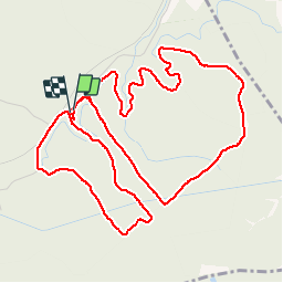

Length
6.9 km

Max alt
385 m

Uphill gradient
141 m
Km-Effort
8.8 km

Min alt
318 m

Downhill gradient
142 m
Boucle
Yes
Creation date :
2019-02-11 14:20:48.956
Updated on :
2019-02-11 16:27:22.671
2h05
Difficulty : Very easy

FREE GPS app for hiking
 SityTrail
IGN / Geographical institutes
SityTrail Plus
The world is yours!
About
Trail Walking of 6.9 km to be discovered at Provence-Alpes-Côte d'Azur, Bouches-du-Rhône, Venelles. This trail is proposed by NADINE52.
Positioning
Country:
France
Region :
Provence-Alpes-Côte d'Azur
Department/Province :
Bouches-du-Rhône
Municipality :
Venelles
Location:
Unknown
Start:(Dec)
Start:(UTM)
702616 ; 4829316 (31T) N.
Comments