


08072013

mikaelerouzic
User
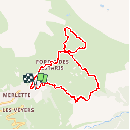

Length
10.5 km

Max alt
2201 m

Uphill gradient
551 m
Km-Effort
17.9 km

Min alt
1716 m

Downhill gradient
551 m
Boucle
Yes
Creation date :
2014-12-10 00:00:00.0
Updated on :
2014-12-10 00:00:00.0
2h36
Difficulty : Medium

FREE GPS app for hiking
 SityTrail
IGN / Geographical institutes
SityTrail Plus
The world is yours!
About
Trail Walking of 10.5 km to be discovered at Provence-Alpes-Côte d'Azur, Hautes-Alpes, Orcières. This trail is proposed by mikaelerouzic.
Positioning
Country:
France
Region :
Provence-Alpes-Côte d'Azur
Department/Province :
Hautes-Alpes
Municipality :
Orcières
Location:
Unknown
Start:(Dec)
Start:(UTM)
288336 ; 4952730 (32T) N.
Comments
Parcours sympa pour une mise en jambes. Il a l'avantage d'être composé de deux boucles. Je vous conseille de faire la 2ème boucle qui vous amène au lac Jujal au milieu des marmottes.