


Mimet 10.28

togolo28
User
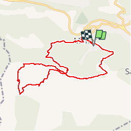

Length
10.3 km

Max alt
738 m

Uphill gradient
620 m
Km-Effort
18.5 km

Min alt
420 m

Downhill gradient
620 m
Boucle
Yes
Creation date :
2019-02-16 13:38:20.277
Updated on :
2019-02-16 13:42:46.631
--
Difficulty : Medium

FREE GPS app for hiking
 SityTrail
IGN / Geographical institutes
SityTrail Plus
The world is yours!
About
Trail On foot of 10.3 km to be discovered at Provence-Alpes-Côte d'Azur, Bouches-du-Rhône, Mimet. This trail is proposed by togolo28.
Positioning
Country:
France
Region :
Provence-Alpes-Côte d'Azur
Department/Province :
Bouches-du-Rhône
Municipality :
Mimet
Location:
Unknown
Start:(Dec)
Start:(UTM)
702991 ; 4809679 (31T) N.
Comments