


mont kokerelle

le.noceur
User

Length
11.2 km

Max alt
113 m

Uphill gradient
134 m
Km-Effort
13 km

Min alt
31 m

Downhill gradient
140 m
Boucle
No
Creation date :
2014-12-10 00:00:00.0
Updated on :
2014-12-10 00:00:00.0
2h21
Difficulty : Unknown

FREE GPS app for hiking
 SityTrail
IGN / Geographical institutes
SityTrail Plus
The world is yours!
About
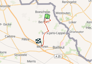
Trail Walking of 11.2 km to be discovered at Hauts-de-France, Nord, Berthen. This trail is proposed by le.noceur.
Description
Mont kokerelle
Positioning
Country:
France
Region :
Hauts-de-France
Department/Province :
Nord
Municipality :
Berthen
Location:
Unknown
Start:(Dec)
Start:(UTM)
478549 ; 5625695 (31U) N.
Comments