


AL Ell

phugues
User
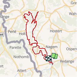

Length
36 km

Max alt
527 m

Uphill gradient
787 m
Km-Effort
46 km

Min alt
272 m

Downhill gradient
792 m
Boucle
No
Creation date :
2019-02-17 09:23:28.712
Updated on :
2019-02-17 12:10:38.412
2h44
Difficulty : Difficult

FREE GPS app for hiking
 SityTrail
IGN / Geographical institutes
SityTrail Plus
The world is yours!
About
Trail Mountain bike of 36 km to be discovered at Unknown, Canton Redange, Ell. This trail is proposed by phugues.
Positioning
Country:
Luxembourg
Region :
Unknown
Department/Province :
Canton Redange
Municipality :
Ell
Location:
Unknown
Start:(Dec)
Start:(UTM)
705456 ; 5516206 (31U) N.
Comments