Trail Walking Orcines - puys de dôme  - Photo
 lefrancm
lefrancm

User

© OpenStreetMap contributors
Length
Length
16.9 km
Max alt
Max alt
1453 m
Uphill gradient
Uphill gradient
754 m
Km-Effort
Km-Effort  
27 km
Min alt
Min alt
892 m
Downhill gradient
Downhill gradient
752 m
Boucle
Boucle
Yes
Creation date :
2014-12-10 00:00:00.0
Updated on :
2014-12-10 00:00:00.0

(0 Reviews)

Walking
Walking
3h25
Difficulty : Easy

Scan this QR Code to open this trail in the SityTrail application

FREE GPS app for hiking

Logo SityTrail SityTrail

IGN / Geographical institutes

Download SityTrail from the App Store Download SityTrail from Google Play

Logo SityTrail SityTrail Plus

The world is yours!

Download SityTrail from the App Store Download SityTrail from Google Play Download SityTrail on Huawei AppGallery

About

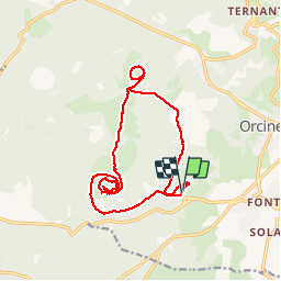
Trail Walking of 16.9 km to be discovered at Auvergne-Rhône-Alpes, Puy-de-Dôme, Orcines. This trail is proposed by lefrancm.

Description

Superbe randonnée ! Le départ se fait grâce au nouveau train qui vous mène au sommet ! Vous profiterez des vues magnifiques puis suiverez le GR 40-441 jusqu au puy pariou. Le retour se fait par le chemin de gouris

Elevation profile

Positioning

Country:
France
Region :
Auvergne-Rhône-Alpes
Department/Province :
Puy-de-Dôme
Municipality :
Orcines
Location:
Unknown
Start:(UTM)
498892 ; 5068582 (31T) N.


Close
My subscriptions