


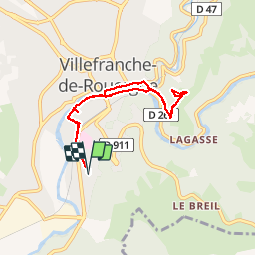
LE CALVAIRE

brigittedelasource
User

Length
7.5 km

Max alt
395 m

Uphill gradient
169 m
Km-Effort
9.8 km

Min alt
251 m

Downhill gradient
169 m
Boucle
Yes
Creation date :
2019-02-17 14:50:09.221
Updated on :
2019-02-17 17:44:40.002
2h48
Difficulty : Very easy

FREE GPS app for hiking
 SityTrail
IGN / Geographical institutes
SityTrail Plus
The world is yours!
About
Trail Walking of 7.5 km to be discovered at Occitania, Aveyron, Villefranche-de-Rouergue. This trail is proposed by brigittedelasource.
Photos


Positioning
Country:
France
Region :
Occitania
Department/Province :
Aveyron
Municipality :
Villefranche-de-Rouergue
Location:
Unknown
Start:(Dec)
Start:(UTM)
423013 ; 4910036 (31T) N.
Comments