


CAMPENEAC 08-07-2012

rousseau.mich
User
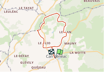

Length
13 km

Max alt
144 m

Uphill gradient
140 m
Km-Effort
14.9 km

Min alt
79 m

Downhill gradient
141 m
Boucle
Yes
Creation date :
2014-12-10 00:00:00.0
Updated on :
2014-12-10 00:00:00.0
2h21
Difficulty : Very easy

FREE GPS app for hiking
 SityTrail
IGN / Geographical institutes
SityTrail Plus
The world is yours!
About
Trail Nordic walking of 13 km to be discovered at Brittany, Morbihan, Campénéac. This trail is proposed by rousseau.mich.
Positioning
Country:
France
Region :
Brittany
Department/Province :
Morbihan
Municipality :
Campénéac
Location:
Unknown
Start:(Dec)
Start:(UTM)
552771 ; 5311772 (30T) N.
Comments