


Métabief

Charles Bolzli
User

Length
21 km

Max alt
1413 m

Uphill gradient
1917 m
Km-Effort
47 km

Min alt
841 m

Downhill gradient
1916 m
Boucle
Yes
Creation date :
2019-02-18 14:05:16.195
Updated on :
2019-02-18 16:05:12.844
1h36
Difficulty : Very easy

FREE GPS app for hiking
 SityTrail
IGN / Geographical institutes
SityTrail Plus
The world is yours!
About
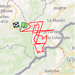
Trail Alpine skiing of 21 km to be discovered at Bourgogne-Franche-Comté, Doubs, Longevilles-Mont-d'Or. This trail is proposed by Charles Bolzli.
Positioning
Country:
France
Region :
Bourgogne-Franche-Comté
Department/Province :
Doubs
Municipality :
Longevilles-Mont-d'Or
Location:
Unknown
Start:(Dec)
Start:(UTM)
296931 ; 5180091 (32T) N.
Comments