


2019-02-24 Balade autour de Niederhaslach

holtzv
User GUIDE
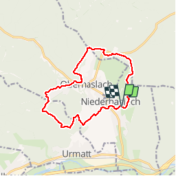

Length
12.9 km

Max alt
396 m

Uphill gradient
318 m
Km-Effort
17.1 km

Min alt
250 m

Downhill gradient
314 m
Boucle
Yes
Creation date :
2019-02-24 12:03:46.733
Updated on :
2019-02-24 14:48:57.13
2h44
Difficulty : Very easy

FREE GPS app for hiking
 SityTrail
IGN / Geographical institutes
SityTrail Plus
The world is yours!
About
Trail Walking of 12.9 km to be discovered at Grand Est, Bas-Rhin, Niederhaslach. This trail is proposed by holtzv.
Positioning
Country:
France
Region :
Grand Est
Department/Province :
Bas-Rhin
Municipality :
Niederhaslach
Location:
Unknown
Start:(Dec)
Start:(UTM)
378033 ; 5377964 (32U) N.
Comments