


Lundi

VANDERPUTTENMi
User GUIDE
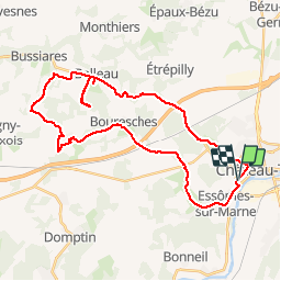

Length
34 km

Max alt
221 m

Uphill gradient
515 m
Km-Effort
41 km

Min alt
59 m

Downhill gradient
514 m
Boucle
Yes
Creation date :
2019-02-25 13:59:00.612
Updated on :
2019-02-25 18:51:06.224
2h18
Difficulty : Very easy

FREE GPS app for hiking
 SityTrail
IGN / Geographical institutes
SityTrail Plus
The world is yours!
About
Trail Mountain bike of 34 km to be discovered at Hauts-de-France, Aisne, Château-Thierry. This trail is proposed by VANDERPUTTENMi.
Positioning
Country:
France
Region :
Hauts-de-France
Department/Province :
Aisne
Municipality :
Château-Thierry
Location:
Unknown
Start:(Dec)
Start:(UTM)
527958 ; 5431961 (31U) N.
Comments