Trail Walking Alajeró - 
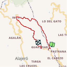
Hermitage Garimiar - Imada - Photo
 mikaou.t
mikaou.t

User

© OpenStreetMap contributors
Length
Length
8.3 km
Max alt
Max alt
907 m
Uphill gradient
Uphill gradient
657 m
Km-Effort
Km-Effort  
17 km
Min alt
Min alt
322 m
Downhill gradient
Downhill gradient
662 m
Boucle
Boucle
No
Creation date :
2019-02-25 11:25:59.957
Updated on :
2019-02-25 17:29:05.082

(1 Reviews)

Walking
Walking
4h12
Difficulty : Difficult

Scan this QR Code to open this trail in the SityTrail application

FREE GPS app for hiking

Logo SityTrail SityTrail

IGN / Geographical institutes

Download SityTrail from the App Store Download SityTrail from Google Play

Logo SityTrail SityTrail Plus

The world is yours!

Download SityTrail from the App Store Download SityTrail from Google Play Download SityTrail on Huawei AppGallery

About

Trail Walking of 8.3 km to be discovered at Canary Islands, Santa Cruz de Tenerife, Alajeró. This trail is proposed by mikaou.t.

Description

superbe circuit. L'Hermitage, petite chapelle à gauche de la route. Se garer, début du sentier face à la chapelle pente en ciment. Peu avant la maison prendre la piste à droite et suivre le tracé GPS.
A Imada, bar où on peut manger aavant de faire la descente inoubliable.

Elevation profile

Positioning

Country:
Spain
Region :
Canary Islands
Department/Province :
Santa Cruz de Tenerife
Municipality :
Alajeró
Location:
Unknown
Start:(UTM)
281765 ; 3106588 (28R) N.

Comments

Please log in to post a review or rate the element


joli sentier panoramique en corniche. Au départ le chemin derrière la maison depuis l'escalier après la pente en béton n'est pas facile à repérer.


Close
My subscriptions