


La Rouge 20.15

togolo28
User
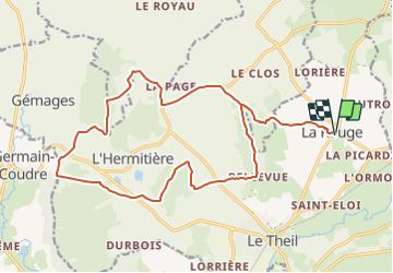

Length
20 km

Max alt
211 m

Uphill gradient
402 m
Km-Effort
26 km

Min alt
108 m

Downhill gradient
403 m
Boucle
Yes
Creation date :
2019-02-26 14:17:43.415
Updated on :
2019-02-26 14:18:06.307
--
Difficulty : Medium

FREE GPS app for hiking
 SityTrail
IGN / Geographical institutes
SityTrail Plus
The world is yours!
About
Trail On foot of 20 km to be discovered at Normandy, Orne, Val-au-Perche. This trail is proposed by togolo28.
Positioning
Country:
France
Region :
Normandy
Department/Province :
Orne
Municipality :
Val-au-Perche
Location:
Unknown
Start:(Dec)
Start:(UTM)
329959 ; 5350669 (31U) N.
Comments