


Ars-Sur-Formans (10 km) le 27-02-2019

Thomasdanielle
User
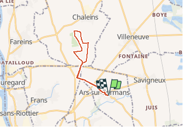

Length
10.4 km

Max alt
263 m

Uphill gradient
82 m
Km-Effort
11.5 km

Min alt
233 m

Downhill gradient
81 m
Boucle
Yes
Creation date :
2019-02-27 12:47:21.772
Updated on :
2019-02-27 12:49:37.765
--
Difficulty : Very easy

FREE GPS app for hiking
 SityTrail
IGN / Geographical institutes
SityTrail Plus
The world is yours!
About
Trail On foot of 10.4 km to be discovered at Auvergne-Rhône-Alpes, Ain, Ars-sur-Formans. This trail is proposed by Thomasdanielle.
Description
Promenade sur le plateau en passants "Les Ardillots" direction Villeneuve
Positioning
Country:
France
Region :
Auvergne-Rhône-Alpes
Department/Province :
Ain
Municipality :
Ars-sur-Formans
Location:
Unknown
Start:(Dec)
Start:(UTM)
640983 ; 5094928 (31T) N.
Comments