Trail Mountain bike Larochemillay - DIMANCHE 14 JUILLET 2013 - Photo
 Tollard
Tollard

User

© OpenStreetMap contributors
Length
Length
56 km
Max alt
Max alt
911 m
Uphill gradient
Uphill gradient
2162 m
Km-Effort
Km-Effort  
85 km
Min alt
Min alt
321 m
Downhill gradient
Downhill gradient
2165 m
Boucle
Boucle
Yes
Creation date :
2015-07-07 00:00:00.0
Updated on :
2015-07-07 00:00:00.0

(2 Reviews)

Mountain bike
Mountain bike
5h17
Difficulty : Difficult

Scan this QR Code to open this trail in the SityTrail application

FREE GPS app for hiking

Logo SityTrail SityTrail

IGN / Geographical institutes

Download SityTrail from the App Store Download SityTrail from Google Play

Logo SityTrail SityTrail World

The world is yours!

Download SityTrail from the App Store Download SityTrail from Google Play Download SityTrail on Huawei AppGallery

About

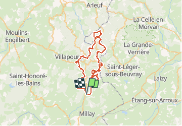
Trail Mountain bike of 56 km to be discovered at Bourgogne-Franche-Comté, Nièvre, Larochemillay. This trail is proposed by Tollard.

Elevation profile

Points of interest

Point of interest Larochemillay - OR-2641490:RAIDTOTO 2013 dimanche version longue 55.937  - Photo
Tollard

Positioning

Country:
France
Region :
Bourgogne-Franche-Comté
Department/Province :
Nièvre
Municipality :
Larochemillay
Location:
Unknown
Start:(Dec)
Start:(UTM)
576288 ; 5192060 (31T) N.

Comments

Please log in to post a review or rate the element


parcours physique, mais de toute beauté


LE SUD MORVAN DANS TOUTE SA SPLENDEUR.ATTENTION / UN BON ENTRAINEMENT S'IMPOSE


Trails nearby

Trail On foot Glux-en-Glenne - Le Tour des Remparts - Photo
On foot
PRO

On foot

Easy
Glux-en-Glenne, Bourgogne-Franche-Comté, Nièvre, France
4.9 km | 6.8 km-effort
1h 32min
Yes
Trail Walking Larochemillay - bois de la vente  - Photo
Walking
martinjacque

Walking

Medium
Larochemillay, Bourgogne-Franche-Comté, Nièvre, France
4.2 km | 5.9 km-effort
1h 47min
Yes
Trail Walking Larochemillay - RIF-04-22-8 du 23.04.2022 - Photo
Walking
bene_dictus77

Walking

Very easy
Larochemillay, Bourgogne-Franche-Comté, Nièvre, France
12.6 km | 15.8 km-effort
3h 35min
No
Trail Walking Larochemillay - raccourci autour du mont Touleur, Larochemillay - Photo
Walking
martinjacque

Walking

Easy
Larochemillay, Bourgogne-Franche-Comté, Nièvre, France
4 km | 5.7 km-effort
1h 52min
Yes
Trail Mountain bike Chiddes - Chiddes - Photo
Mountain bike
ben

Mountain bike

Chiddes, Bourgogne-Franche-Comté, Nièvre, France
19 km | 26 km-effort
1h 42min
Yes
Trail Walking Glux-en-Glenne - Mont Beuvray 28 - Photo
Walking
togolo28

Walking

Medium
Glux-en-Glenne, Bourgogne-Franche-Comté, Nièvre, France
28 km | 41 km-effort
8h 34min
Yes
Trail Walking Chiddes - Chiddes - Photo
Walking
Bobol

Walking

Medium
(1)
Chiddes, Bourgogne-Franche-Comté, Nièvre, France
10.3 km | 13.4 km-effort
2h 52min
Yes
Trail Walking Larochemillay - Larochemillay-Crot des hâtes - Photo
Walking
martinjacque

Walking

Easy
Larochemillay, Bourgogne-Franche-Comté, Nièvre, France
6 km | 8.4 km-effort
2h 2min
Yes
Trail Walking Millay - Circuit du Bois de Velle - Photo
Walking
martinjacque

Walking

Very easy
Millay, Bourgogne-Franche-Comté, Nièvre, France
8.8 km | 11.5 km-effort
2h 27min
Yes


Close
My subscriptions