


Ars-s-formans (Cibeins)

Thomasdanielle
User

Length
4.3 km

Max alt
260 m

Uphill gradient
73 m
Km-Effort
5.3 km

Min alt
221 m

Downhill gradient
73 m
Boucle
Yes
Creation date :
2019-02-27 15:53:52.0
Updated on :
2019-02-27 18:07:07.759
1h14
Difficulty : Easy

FREE GPS app for hiking
 SityTrail
IGN / Geographical institutes
SityTrail Plus
The world is yours!
About
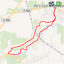
Trail Walking of 4.3 km to be discovered at Auvergne-Rhône-Alpes, Ain, Ars-sur-Formans. This trail is proposed by Thomasdanielle.
Description
D/À parking centre village
Tour du bois de Cibeins le 27/02/19 par une belle journée ensoleillée, ça sentais le printemps
Photos
 - Photo 1")
 - Photo 2")
 - Photo 3")
Positioning
Country:
France
Region :
Auvergne-Rhône-Alpes
Department/Province :
Ain
Municipality :
Ars-sur-Formans
Location:
Unknown
Start:(Dec)
Start:(UTM)
640855 ; 5094984 (31T) N.
Comments