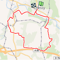
Chessy-les-mines (9,7 km-D. 251)

Thomasdanielle
User


2h56
Difficulty : Easy

FREE GPS app for hiking
 SityTrail
IGN / Geographical institutes
SityTrail Plus
The world is yours!
About
Trail Walking of 9.7 km to be discovered at Auvergne-Rhône-Alpes, Rhône, Chessy. This trail is proposed by Thomasdanielle.
Description
D/A Parking en face le terrain de tennis.
Randonnée facile.
Il faut prendre le passage souterrain afin de voir toutes des peintures de tous les village autour de Chessy. Prendre le temps de visiter ce magnifique village (cité Galo-Romaine), avec une magnifique Eglise, il ne faut pas passer à côté de ce patrimoine exceptionnel. Ce village est à environ 20 km de Villefranche-sur-Saône.
Positioning
Comments