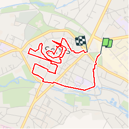
SENLIS CITE ROYALE(FFK)

GR77LP
User

Length
4.6 km

Max alt
82 m

Uphill gradient
41 m
Km-Effort
5.2 km

Min alt
53 m

Downhill gradient
39 m
Boucle
Yes
Creation date :
2019-03-03 11:04:53.838
Updated on :
2019-03-23 19:43:04.97
2h00
Difficulty : Very easy

FREE GPS app for hiking
 SityTrail
IGN / Geographical institutes
SityTrail Plus
The world is yours!
About
Trail On foot of 4.6 km to be discovered at Hauts-de-France, Oise, Senlis. This trail is proposed by GR77LP.
Photos
 - Photo 1")
Positioning
Country:
France
Region :
Hauts-de-France
Department/Province :
Oise
Municipality :
Senlis
Location:
Unknown
Start:(Dec)
Start:(UTM)
470286 ; 5450442 (31U) N.
Comments