


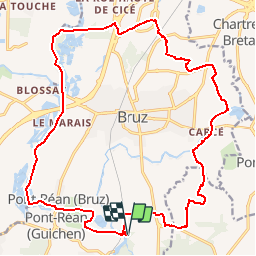
Autour de Bruz

chasle
User

Length
22 km

Max alt
62 m

Uphill gradient
182 m
Km-Effort
25 km

Min alt
12 m

Downhill gradient
183 m
Boucle
Yes
Creation date :
2019-03-03 11:05:31.105
Updated on :
2019-03-03 11:06:51.931
5h29
Difficulty : Easy

FREE GPS app for hiking
 SityTrail
IGN / Geographical institutes
SityTrail Plus
The world is yours!
About
Trail Walking of 22 km to be discovered at Brittany, Ille-et-Vilaine, Bruz. This trail is proposed by chasle.
Positioning
Country:
France
Region :
Brittany
Department/Province :
Ille-et-Vilaine
Municipality :
Bruz
Location:
Unknown
Start:(Dec)
Start:(UTM)
593228 ; 5316641 (30T) N.
Comments