


SityTrail - le gabas MN2

LouisROGER
User GUIDE
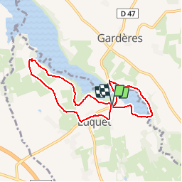

Length
8 km

Max alt
388 m

Uphill gradient
98 m
Km-Effort
9.3 km

Min alt
352 m

Downhill gradient
100 m
Boucle
Yes
Creation date :
2019-03-03 12:30:57.562
Updated on :
2019-03-03 12:33:47.28
1h30
Difficulty : Easy

FREE GPS app for hiking
 SityTrail
IGN / Geographical institutes
SityTrail Plus
The world is yours!
About
Trail Nordic walking of 8 km to be discovered at Occitania, Hautespyrenees, Luquet. This trail is proposed by LouisROGER.
Positioning
Country:
France
Region :
Occitania
Department/Province :
Hautespyrenees
Municipality :
Luquet
Location:
Unknown
Start:(Dec)
Start:(UTM)
734190 ; 4794556 (30T) N.
Comments