


SityTrail - bois d oroix Mn2

LouisROGER
User GUIDE
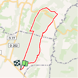

Length
7.7 km

Max alt
381 m

Uphill gradient
125 m
Km-Effort
9.3 km

Min alt
280 m

Downhill gradient
125 m
Boucle
Yes
Creation date :
2019-03-03 12:37:09.521
Updated on :
2019-03-03 12:38:16.617
2h01
Difficulty : Medium
1h30
Difficulty : Easy

FREE GPS app for hiking
 SityTrail
IGN / Geographical institutes
SityTrail Plus
The world is yours!
About
Trail Walking of 7.7 km to be discovered at Occitania, Hautespyrenees, Oroix. This trail is proposed by LouisROGER.
Positioning
Country:
France
Region :
Occitania
Department/Province :
Hautespyrenees
Municipality :
Oroix
Location:
Unknown
Start:(Dec)
Start:(UTM)
742237 ; 4797341 (30T) N.
Comments
bonne journée