


07 Fonjas Chalancon

HAL26
User
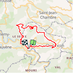

Length
15.5 km

Max alt
835 m

Uphill gradient
627 m
Km-Effort
24 km

Min alt
307 m

Downhill gradient
627 m
Boucle
Yes
Creation date :
2019-03-03 09:44:54.642
Updated on :
2019-03-03 15:29:48.48
4h54
Difficulty : Very easy

FREE GPS app for hiking
 SityTrail
IGN / Geographical institutes
SityTrail Plus
The world is yours!
About
Trail Walking of 15.5 km to be discovered at Auvergne-Rhône-Alpes, Ardèche, Chalencon. This trail is proposed by HAL26.
Positioning
Country:
France
Region :
Auvergne-Rhône-Alpes
Department/Province :
Ardèche
Municipality :
Chalencon
Location:
Unknown
Start:(Dec)
Start:(UTM)
621775 ; 4970170 (31T) N.
Comments