


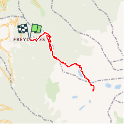
Refuge de la Pra par le lac de Crouzet

florent43
User

Length
16.6 km

Max alt
2166 m

Uphill gradient
1108 m
Km-Effort
31 km

Min alt
1142 m

Downhill gradient
1107 m
Boucle
Yes
Creation date :
2014-12-10 00:00:00.0
Updated on :
2014-12-10 00:00:00.0
6h00
Difficulty : Difficult

FREE GPS app for hiking
 SityTrail
IGN / Geographical institutes
SityTrail Plus
The world is yours!
About
Trail Walking of 16.6 km to be discovered at Auvergne-Rhône-Alpes, Isère, Revel. This trail is proposed by florent43.
Description
Départ du lac des Freydières
Passage par le lac du Crozet
Passage par le Col de la Pra (2164m d'altitude)
Retour par le même itinéraire.
Positioning
Country:
France
Region :
Auvergne-Rhône-Alpes
Department/Province :
Isère
Municipality :
Revel
Location:
Unknown
Start:(Dec)
Start:(UTM)
727783 ; 5007805 (31T) N.
Comments