


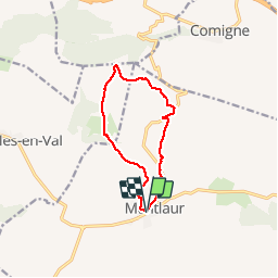
Montlaur 07 03 19

DENNEBECQ
User

Length
10.7 km

Max alt
358 m

Uphill gradient
264 m
Km-Effort
14.2 km

Min alt
192 m

Downhill gradient
265 m
Boucle
Yes
Creation date :
2019-03-07 14:02:45.489
Updated on :
2019-03-07 17:15:47.191
3h11
Difficulty : Very easy

FREE GPS app for hiking
 SityTrail
IGN / Geographical institutes
SityTrail Plus
The world is yours!
About
Trail Walking of 10.7 km to be discovered at Occitania, Aude, Val-de-Dagne. This trail is proposed by DENNEBECQ.
Positioning
Country:
France
Region :
Occitania
Department/Province :
Aude
Municipality :
Val-de-Dagne
Location:
Unknown
Start:(Dec)
Start:(UTM)
464061 ; 4775191 (31T) N.
Comments