


SityTrail - Circuit des Trois villages G3

LouisROGER
User GUIDE
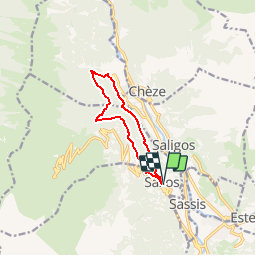

Length
9.4 km

Max alt
1188 m

Uphill gradient
463 m
Km-Effort
15.6 km

Min alt
802 m

Downhill gradient
468 m
Boucle
Yes
Creation date :
2019-03-07 21:27:31.917
Updated on :
2019-03-07 21:29:26.762
3h10
Difficulty : Difficult

FREE GPS app for hiking
 SityTrail
IGN / Geographical institutes
SityTrail Plus
The world is yours!
About
Trail Walking of 9.4 km to be discovered at Occitania, Hautespyrenees, Sazos. This trail is proposed by LouisROGER.
Positioning
Country:
France
Region :
Occitania
Department/Province :
Hautespyrenees
Municipality :
Sazos
Location:
Unknown
Start:(Dec)
Start:(UTM)
743014 ; 4752150 (30T) N.
Comments
superbe