Trail Walking Bagnols-en-Forêt - Bagnols en Forêt - Pierre du coucou - Pic de la Gardiette - Photo

Bagnols en Forêt - Pierre du coucou - Pic de la Gardiette

 soca
soca

User

© OpenStreetMap contributors
Length
Length
11.1 km
Max alt
Max alt
419 m
Uphill gradient
Uphill gradient
386 m
Km-Effort
Km-Effort  
16.3 km
Min alt
Min alt
223 m
Downhill gradient
Downhill gradient
388 m
Boucle
Boucle
Yes
Creation date :
2019-03-07 08:55:41.364
Updated on :
2019-03-08 03:01:14.855

(1 Reviews)

Walking
Walking
5h58
Difficulty : Very easy

Scan this QR Code to open this trail in the SityTrail application

FREE GPS app for hiking

Logo SityTrail SityTrail

IGN / Geographical institutes

Download SityTrail from the App Store Download SityTrail from Google Play

Logo SityTrail SityTrail Plus

The world is yours!

Download SityTrail from the App Store Download SityTrail from Google Play Download SityTrail on Huawei AppGallery

About

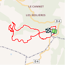
Trail Walking of 11.1 km to be discovered at Provence-Alpes-Côte d'Azur, Var, Bagnols-en-Forêt. This trail is proposed by soca.

Description

Belle rando. A voir :
- l'oppidum de la forteresse d'où nous avons une vue splendide sur la vallée  au pied de Bagnols.
- le site des meuliéres où les traces de la taille des meules est encore trés visible.

Elevation profile

Positioning

Country:
France
Region :
Provence-Alpes-Côte d'Azur
Department/Province :
Var
Municipality :
Bagnols-en-Forêt
Location:
Unknown
Start:(UTM)
315947 ; 4820845 (32T) N.

Comments

Please log in to post a review or rate the element


Tracé à revoir sur 2 premiers km suite à la construction du stockage de déchets.


Close
My subscriptions