


Col de Bertagne depuis Plan d'Aups

Seylinn
User

Length
7.5 km

Max alt
912 m

Uphill gradient
298 m
Km-Effort
11.4 km

Min alt
686 m

Downhill gradient
298 m
Boucle
Yes
Creation date :
2019-03-10 17:23:33.84
Updated on :
2019-03-10 17:25:29.631
2h12
Difficulty : Easy

FREE GPS app for hiking
 SityTrail
IGN / Geographical institutes
SityTrail Plus
The world is yours!
About
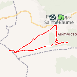
Trail Walking of 7.5 km to be discovered at Provence-Alpes-Côte d'Azur, Var, Plan-d'Aups-Sainte-Baume. This trail is proposed by Seylinn.
Description
23/02/2019
Il faut continuer le sentier qui part dans le sens inverse du col de Bertagne, c'est normal, avant de retomber sur le piste.
02h12
Positioning
Country:
France
Region :
Provence-Alpes-Côte d'Azur
Department/Province :
Var
Municipality :
Plan-d'Aups-Sainte-Baume
Location:
Unknown
Start:(Dec)
Start:(UTM)
719986 ; 4800732 (31T) N.
Comments