


Ruisseau de Fontgraze

pb07
User
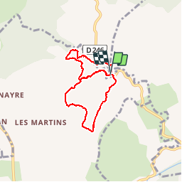

Length
6.9 km

Max alt
199 m

Uphill gradient
110 m
Km-Effort
8.4 km

Min alt
157 m

Downhill gradient
112 m
Boucle
Yes
Creation date :
2019-03-10 14:52:23.511
Updated on :
2019-03-10 23:36:19.409
2h02
Difficulty : Very easy

FREE GPS app for hiking
 SityTrail
IGN / Geographical institutes
SityTrail Plus
The world is yours!
About
Trail Walking of 6.9 km to be discovered at Auvergne-Rhône-Alpes, Ardèche, Saint-Alban-Auriolles. This trail is proposed by pb07.
Positioning
Country:
France
Region :
Auvergne-Rhône-Alpes
Department/Province :
Ardèche
Municipality :
Saint-Alban-Auriolles
Location:
Unknown
Start:(Dec)
Start:(UTM)
600143 ; 4920284 (31T) N.
Comments