Trail Walking Levens - 
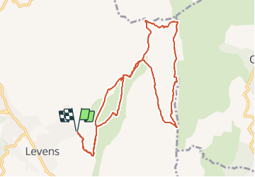
Mont Ferion par Levens - Photo
 GrouGary
GrouGary

User

© OpenStreetMap contributors
Length
Length
12.3 km
Max alt
Max alt
1397 m
Uphill gradient
Uphill gradient
785 m
Km-Effort
Km-Effort  
23 km
Min alt
Min alt
618 m
Downhill gradient
Downhill gradient
787 m
Boucle
Boucle
Yes
Creation date :
2019-03-10 09:31:34.969
Updated on :
2021-11-23 17:25:33.068

(0 Reviews)

Walking
Walking
4h45
Difficulty : Easy

Scan this QR Code to open this trail in the SityTrail application

FREE GPS app for hiking

Logo SityTrail SityTrail

IGN / Geographical institutes

Download SityTrail from the App Store Download SityTrail from Google Play

Logo SityTrail SityTrail Plus

The world is yours!

Download SityTrail from the App Store Download SityTrail from Google Play Download SityTrail on Huawei AppGallery

About

Trail Walking of 12.3 km to be discovered at Provence-Alpes-Côte d'Azur, Maritime Alps, Levens. This trail is proposed by GrouGary.

Description

Belle rando de printemps, sans difficultés techniques. A faire après la sortie des très nombreuses chenilles processionnaires et avant les chaleurs. Beaux point de vue sur la crête du Férion côté Est vers Coaraze.

Elevation profile

Positioning

Country:
France
Region :
Provence-Alpes-Côte d'Azur
Department/Province :
Maritime Alps
Municipality :
Levens
Location:
Unknown
Start:(UTM)
359243 ; 4856839 (32T) N.


Close
My subscriptions