


Puy-saint-Romain

Chapatann
User
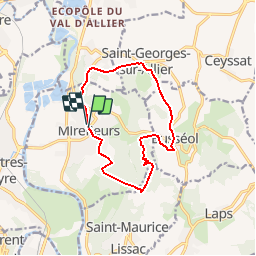

Length
11.8 km

Max alt
768 m

Uphill gradient
502 m
Km-Effort
18.5 km

Min alt
393 m

Downhill gradient
511 m
Boucle
Yes
Creation date :
2014-12-10 00:00:00.0
Updated on :
2014-12-10 00:00:00.0
10h00
Difficulty : Unknown

FREE GPS app for hiking
 SityTrail
IGN / Geographical institutes
SityTrail Plus
The world is yours!
About
Trail Other activity of 11.8 km to be discovered at Auvergne-Rhône-Alpes, Puy-de-Dôme, Mirefleurs. This trail is proposed by Chapatann.
Positioning
Country:
France
Region :
Auvergne-Rhône-Alpes
Department/Province :
Puy-de-Dôme
Municipality :
Mirefleurs
Location:
Unknown
Start:(Dec)
Start:(UTM)
517498 ; 5060162 (31T) N.
Comments