


ST TROPEZ ENVIRON

michelpaulin
User
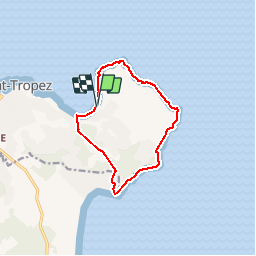

Length
11.2 km

Max alt
90 m

Uphill gradient
192 m
Km-Effort
13.8 km

Min alt
0 m

Downhill gradient
190 m
Boucle
Yes
Creation date :
2019-03-12 10:24:36.298
Updated on :
2019-03-12 16:00:00.266
5h34
Difficulty : Easy

FREE GPS app for hiking
 SityTrail
IGN / Geographical institutes
SityTrail Plus
The world is yours!
About
Trail Walking of 11.2 km to be discovered at Provence-Alpes-Côte d'Azur, Var, Saint-Tropez. This trail is proposed by michelpaulin.
Description
chemon des canebiers
Positioning
Country:
France
Region :
Provence-Alpes-Côte d'Azur
Department/Province :
Var
Municipality :
Saint-Tropez
Location:
Unknown
Start:(Dec)
Start:(UTM)
310849 ; 4793126 (32T) N.
Comments