


villefranche-entraygues

frank12
User
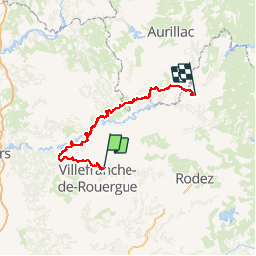

Length
177 km

Max alt
785 m

Uphill gradient
4824 m
Km-Effort
242 km

Min alt
157 m

Downhill gradient
5071 m
Boucle
No
Creation date :
2019-03-16 23:55:13.503
Updated on :
2019-03-29 18:24:52.17
--
Difficulty : Medium

FREE GPS app for hiking
 SityTrail
IGN / Geographical institutes
SityTrail Plus
The world is yours!
About
Trail Moto cross of 177 km to be discovered at Occitania, Aveyron, Maleville. This trail is proposed by frank12.
Description
a reconnaitre
Positioning
Country:
France
Region :
Occitania
Department/Province :
Aveyron
Municipality :
Maleville
Location:
Unknown
Start:(Dec)
Start:(UTM)
426535 ; 4916489 (31T) N.
Comments