


Col du Bougnon N/O. Valcologne

Sugg
User
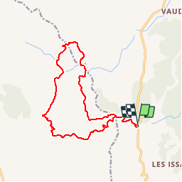

Length
17.6 km

Max alt
321 m

Uphill gradient
541 m
Km-Effort
25 km

Min alt
60 m

Downhill gradient
543 m
Boucle
Yes
Creation date :
2019-03-19 19:45:06.626
Updated on :
2019-03-19 19:47:43.554
5h13
Difficulty : Medium

FREE GPS app for hiking
 SityTrail
IGN / Geographical institutes
SityTrail Plus
The world is yours!
About
Trail Walking of 17.6 km to be discovered at Provence-Alpes-Côte d'Azur, Var, Roquebrune-sur-Argens. This trail is proposed by Sugg.
Description
Projer rando RF à reconnaitre pour le 26 juin 2019.
Positioning
Country:
France
Region :
Provence-Alpes-Côte d'Azur
Department/Province :
Var
Municipality :
Roquebrune-sur-Argens
Location:
Unknown
Start:(Dec)
Start:(UTM)
311430 ; 4803778 (32T) N.
Comments