


2019 03 20 Chambles Essalois

psesjs
User
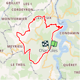

Length
18.2 km

Max alt
734 m

Uphill gradient
478 m
Km-Effort
25 km

Min alt
428 m

Downhill gradient
478 m
Boucle
Yes
Creation date :
2019-03-20 08:21:26.089
Updated on :
2019-03-20 16:38:47.327
6h24
Difficulty : Medium

FREE GPS app for hiking
 SityTrail
IGN / Geographical institutes
SityTrail Plus
The world is yours!
About
Trail Walking of 18.2 km to be discovered at Auvergne-Rhône-Alpes, Loire, Chambles. This trail is proposed by psesjs.
Photos


Positioning
Country:
France
Region :
Auvergne-Rhône-Alpes
Department/Province :
Loire
Municipality :
Chambles
Location:
Unknown
Start:(Dec)
Start:(UTM)
596904 ; 5032776 (31T) N.
Comments