Trail On foot Mauves - Mauves, Les Champs - Photo
© OpenStreetMap contributors
Length
Length
8.8 km
Max alt
Max alt
374 m
Uphill gradient
Uphill gradient
347 m
Km-Effort
Km-Effort  
13.4 km
Min alt
Min alt
123 m
Downhill gradient
Downhill gradient
347 m
Boucle
Boucle
Yes
Creation date :
2019-03-21 06:51:35.7
Updated on :
2019-03-21 07:22:18.295

(0 Reviews)

On foot
On foot
--
Difficulty : Easy

Scan this QR Code to open this trail in the SityTrail application

FREE GPS app for hiking

Logo SityTrail SityTrail

IGN / Geographical institutes

Download SityTrail from the App Store Download SityTrail from Google Play

Logo SityTrail SityTrail World

The world is yours!

Download SityTrail from the App Store Download SityTrail from Google Play Download SityTrail on Huawei AppGallery

About

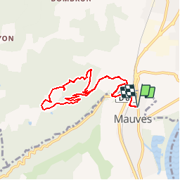
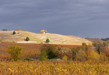
Trail On foot of 8.8 km to be discovered at Auvergne-Rhône-Alpes, Ardèche, Mauves. This trail is proposed by bernadette revoux.

Description

Topoguide de Tournon-sur-Rhône
fiche rando 9
"Une balade très agréable entre vignes et ambiances méditerrannéennes en dominant la vallée du Rhône"

Elevation profile

Positioning

Country:
France
Region :
Auvergne-Rhône-Alpes
Department/Province :
Ardèche
Municipality :
Mauves
Location:
Unknown
Start:(UTM)
644133 ; 4989098 (31T) N.

Trails nearby

Trail Mountain bike Tournon-sur-Rhône - Rando des tours 2009 - Photo
Mountain bike
ramsay

Mountain bike

Difficult
(1)
Tournon-sur-Rhône, Auvergne-Rhône-Alpes, Ardèche, France
40 km | 53 km-effort
3h 23min
Yes
Trail sport La Roche-de-Glun - La Roche de Glun rando école  - Photo
sport
alinetpierre

sport

Very easy
La Roche-de-Glun, Auvergne-Rhône-Alpes, Drôme, France
11.4 km | 15.7 km-effort
Unknown
Yes
Trail Walking Tain-l'Hermitage - Tain l’Hermitage Croze   - Photo
Walking
alinetpierre

Walking

Medium
Tain-l'Hermitage, Auvergne-Rhône-Alpes, Drôme, France
7.8 km | 12 km-effort
2h 5min
Yes
Trail Walking Glun - Glun Ardèche  - Photo
Walking
alinetpierre

Walking

Medium
Glun, Auvergne-Rhône-Alpes, Ardèche, France
13.3 km | 18.8 km-effort
2h 58min
Yes
Trail Mountain bike Tournon-sur-Rhône - Tournon-Meyras par la route-retour Tournon 21km  520m - Photo
Mountain bike
micheljullien

Mountain bike

Medium
(1)
Tournon-sur-Rhône, Auvergne-Rhône-Alpes, Ardèche, France
21 km | 28 km-effort
1h 54min
Yes
Trail Walking Tain-l'Hermitage - Gare Tain /Gite  Bonnefontaine Plats  par Mauves  - Photo
Walking
jacquesdunogier

Walking

Easy
Tain-l'Hermitage, Auvergne-Rhône-Alpes, Drôme, France
17.8 km | 24 km-effort
5h 23min
No
Trail Walking Tain-l'Hermitage - Tain 14km - Photo
Walking
GUIDE
thonyc

Walking

Very difficult
Tain-l'Hermitage, Auvergne-Rhône-Alpes, Drôme, France
14 km | 21 km-effort
4h 44min
Yes
Trail Walking Mauves - Mauves  - Photo
Walking
bernadette revoux

Walking

Easy
Mauves, Auvergne-Rhône-Alpes, Ardèche, France
14.8 km | 22 km-effort
3h 51min
Yes
Trail Walking Tournon-sur-Rhône - F07300_Mauve_LT_AM_DS - Photo
Walking
ageo

Walking

Easy
(1)
Tournon-sur-Rhône, Auvergne-Rhône-Alpes, Ardèche, France
11.2 km | 16.2 km-effort
4h 0min
Yes


Close
My subscriptions