


20190321olloy

michelelfn
User
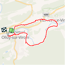

Length
7.4 km

Max alt
234 m

Uphill gradient
150 m
Km-Effort
9.4 km

Min alt
130 m

Downhill gradient
151 m
Boucle
Yes
Creation date :
2019-03-21 13:01:38.592
Updated on :
2019-03-21 15:36:47.326
2h34
Difficulty : Very easy

FREE GPS app for hiking
 SityTrail
IGN / Geographical institutes
SityTrail Plus
The world is yours!
About
Trail Walking of 7.4 km to be discovered at Wallonia, Namur, Viroinval. This trail is proposed by michelelfn.
Positioning
Country:
Belgium
Region :
Wallonia
Department/Province :
Namur
Municipality :
Viroinval
Location:
Olloy-sur-Viroin
Start:(Dec)
Start:(UTM)
614670 ; 5548007 (31U) N.
Comments