


Mons en Laonnois

VANDERPUTTENMi
User GUIDE
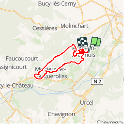

Length
19.9 km

Max alt
192 m

Uphill gradient
416 m
Km-Effort
25 km

Min alt
69 m

Downhill gradient
415 m
Boucle
Yes
Creation date :
2019-03-24 07:49:41.741
Updated on :
2019-03-24 13:26:00.821
5h34
Difficulty : Very easy

FREE GPS app for hiking
 SityTrail
IGN / Geographical institutes
SityTrail Plus
The world is yours!
About
Trail Walking of 19.9 km to be discovered at Hauts-de-France, Aisne, Mons-en-Laonnois. This trail is proposed by VANDERPUTTENMi.
Positioning
Country:
France
Region :
Hauts-de-France
Department/Province :
Aisne
Municipality :
Mons-en-Laonnois
Location:
Unknown
Start:(Dec)
Start:(UTM)
540589 ; 5487247 (31U) N.
Comments