


St sulpice la Forêt

chasle
User
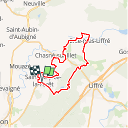

Length
27 km

Max alt
114 m

Uphill gradient
325 m
Km-Effort
32 km

Min alt
47 m

Downhill gradient
326 m
Boucle
Yes
Creation date :
2019-03-27 08:45:00.204
Updated on :
2019-03-27 16:23:38.359
6h36
Difficulty : Very easy

FREE GPS app for hiking
 SityTrail
IGN / Geographical institutes
SityTrail Plus
The world is yours!
About
Trail Walking of 27 km to be discovered at Brittany, Ille-et-Vilaine, Saint-Sulpice-la-Forêt. This trail is proposed by chasle.
Positioning
Country:
France
Region :
Brittany
Department/Province :
Ille-et-Vilaine
Municipality :
Saint-Sulpice-la-Forêt
Location:
Unknown
Start:(Dec)
Start:(UTM)
605443 ; 5341494 (30U) N.
Comments