


St Ouen sur Iton 17.38

togolo28
User
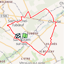

Length
17.4 km

Max alt
238 m

Uphill gradient
122 m
Km-Effort
19 km

Min alt
193 m

Downhill gradient
123 m
Boucle
Yes
Creation date :
2019-03-28 14:22:38.277
Updated on :
2019-09-13 16:16:33.362
4h07
Difficulty : Medium

FREE GPS app for hiking
 SityTrail
IGN / Geographical institutes
SityTrail Plus
The world is yours!
About
Trail Walking of 17.4 km to be discovered at Normandy, Orne, Saint-Ouen-sur-Iton. This trail is proposed by togolo28.
Positioning
Country:
France
Region :
Normandy
Department/Province :
Orne
Municipality :
Saint-Ouen-sur-Iton
Location:
Unknown
Start:(Dec)
Start:(UTM)
330497 ; 5400586 (31U) N.
Comments