


Chevreuse

prv
User
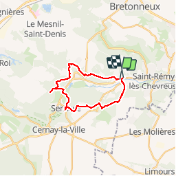

Length
18.8 km

Max alt
178 m

Uphill gradient
448 m
Km-Effort
25 km

Min alt
78 m

Downhill gradient
445 m
Boucle
No
Creation date :
2019-03-30 11:00:48.557
Updated on :
2019-03-30 15:41:09.151
4h39
Difficulty : Medium

FREE GPS app for hiking
 SityTrail
IGN / Geographical institutes
SityTrail Plus
The world is yours!
About
Trail Walking of 18.8 km to be discovered at Ile-de-France, Yvelines, Chevreuse. This trail is proposed by prv.
Description
ravi
Positioning
Country:
France
Region :
Ile-de-France
Department/Province :
Yvelines
Municipality :
Chevreuse
Location:
Unknown
Start:(Dec)
Start:(UTM)
429051 ; 5395283 (31U) N.
Comments
une belle promenade dans un environment bucolique ! A découvrir ! Attention pas de ravitaillement en dehors de Chevreuse.